Présentation
- La route nationale 334, ou RN334, est une ancienne route nationale française qui faisait partie de la Rocade de Béziers.
Historique
- A sa création, en 1933, elle est définie comme la route de Coucy-le-Château à Amiens.
- Le trajet de Boves à Amiens se faisait alors via la N35.
- Elle possédait une annexe, la N334A.
- Le tracé reprend une ancienne voie romaine reliant Amiens à Soissons.
- Il est à signaler qu'une seconde chaussée a été construite entre Roye (autoroute A1) et Boves (Amiens, autoroute A29) le long de la chaussée originale. Ce système économique se traduit par des déviations unidirectionnelles. Elle est mise en service en août 1969. Sa mise aux normes avec doublement et dénivellation des échanges est programmée mais elle est victime d'arbitrages budgétaires défavorables du Conseil Départemental de la Somme. Seul un diffuseur a été réalisé à Démuin en 2002.
- En 1973, la RN334 a été déclassée en D934, sauf dans la traversée de Roye où elle est devenue la D34, la D934 correspondant alors à la rocade nord de la ville.
- Le numéro récupéré en 2002 pour la Rocade de Béziers.
- A l'origine, l'intégralité de la rocade de Béziers devait être nommée RN334 en replacement de la RN1112.
- Cependant, ce ne fut pas le cas, et seul un tronçon au nord fut appelé comme tel (entre les RN9 et RN112).
- La Rocade de Béziers est depuis 2006 passée intégralement dans le réseau départemental de l'Hérault.
Tracés historiques
Rocade de Béziers (avant 2006)
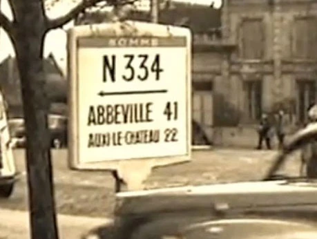
Ce faux Panneau Michelin de la RN334, capturé par Raphaël Saunier sur une vidéo, est un mystère. Il indique des directions de la RN41 à Saint-Pol-sur-Ternoise, aucun rapport avec la RN334, donc...
- Hérault (34) - D612
 D612 Cers, Vias, Agde, D612B Béziers-Centre, Villeneuve-lès-Béziers
 Z.A.C. Claudery, Z.A.C. Montagnette
 D612
D612- A9 Sète, Montpellier, Nîmes, Lyon, Narbonne, Perpignan, Toulouse, A75 Pézenas, Millau, Clermont-Ferrand, Béziers-Centre, Stade de la Méditerranée
- Stade de la Méditerranée, Montimaran
- D612
- (Rond-Point Vincent Badie) Béziers-Centre, Bessan, Z.A.C. Giniesse
- Z.A.C. La Crouzette (quart-échangeur)
- (Rond-Point Edgar Faure) N9 Valros, vers A75 (Pézenas, Millau, Clermont-Ferrand), D609 Béziers-Centre
- D612
- D909 Béziers-Centre, Lieuran-lès-Béziers, Puimisson, Bédarieux
- Béziers-Centre, Corneilhan
- D19 Béziers-Centre, Lignan-sur-Orb, Murviel-lès-Béziers
- D14 Béziers-Centre, Maraussan, Cazouls-lès-Béziers, Cessenon-sur-Orb
- D612
- D612 Béziers-Centre, Maureilhan, Saint-Chinian, Saint-Pons-de-Thomières, Mazamet, Castres
Coucy-le-Château-Auffrique - Boves (avant 1973)
- Aisne (02) D934
- Oise (60) D934
- Somme (80) D934
Voir Aussi
Liens Internes
Articles Connexes
Liens SARA
- Aucun lien pour l'instant
Lien Externe
- [DR] Les Grands Travaux dans l'Hérault : renseignements sur l'aménagement de la RN334 (rocade de Béziers)
| ||||||||