- Pour les articles homonymes, voir Route nationale 2001 (Homonymie).

Sommaire
Présentation[]
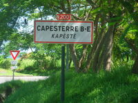
- La route nationale 2001 (971), ou RN2001 (971), est une route nationale française qui correspond à l'ancien tracé de la RN1, lorsque celle-ci empruntait la célèbre Allée Dumanoir et traversait l'agglomération de Capesterre-Belle-Eau.
Historique[]
- Avant 2005, le numéro avait été brièvement attribué à d'autres anciens tracés de cette route nationale, entre le moment où ils ont été déviés et celui où ils ont été formellement déclassés :
- ancien tracé entre l'Habitation La Coulisse à Trois-Rivières et Le Trou-aux-Chiens, déclassé dans la voirie communale le 22 décembre 1973 ;
- ancien tracé au droit de Carangaise à Capesterre-Belle-Eau, déclassé dans la voirie communale le 23 octobre 1974 ;
- ancien tracé à Baie-Mahault, devant le Camp Dugommier, déclassé dans la voirie communale le 4 octobre 1983 ;
- ancien tracé entre Dos-d'Âne à Gourbeyre et Sapotille à Trois-Rivières, déclassé dans la voirie départementale le 1er février 1984 en tant que D7 et D6 ;
- ancien tracé à Basse-Terre et Gourbeyre, déclassé le 4 mai 1985 dans les voiries communales et la voirie départementale en tant que D6, D9 et D10 ;
- ancien tracé à Goyave, déclassé dans la voirie départementale le 19 septembre 1986 en tant que D33 ;
- ancien tracé entre La Rose à Goyave et La Lézarde à Petit-Bourg, déclassé dans la voirie départementale au milieu des années 2000 en tant que D33 (déviation mise en service en octobre 1997).
- La déviation de Capesterre-Belle-Eau est mise en service le 3 juin 2004.
- Suite à la réforme de 2005, la RN2001 a été transférée au Conseil Régional de la Guadeloupe dans son intégralité, mais elle a conservé son numéro et ses signaux routiers.
Futur[]
- Aucun projet connu à ce jour.
Autour de la route[]
- L'Allée Dumanoir
Tracés historiques[]
A Capesterre-Belle-Eau (Depuis 2004)[]

Portique de signalisation sur la RN1 en provenance de Basse-Terre
© Dark_green67
Chargement de la carte...
{"type":"HYBRID","minzoom":false,"maxzoom":false,"types":["ROADMAP","SATELLITE","HYBRID","TERRAIN"],"mappingservice":"googlemaps3","width":"450px","height":"450px","centre":{"text":"","title":"","link":"","lat":16.038,"lon":-61.56844,"icon":""},"title":"","label":"","icon":"","lines":[{"text":"\u003Cdiv class=\"mw-parser-output\"\u003E\u003Cp\u003ETrac\u00e9 actuel de la RN2001\n\u003C/p\u003E\u003C/div\u003E","title":"Trac\u00e9 actuel de la RN2001\n","link":"","strokeColor":"#F30A2B","strokeOpacity":"1","strokeWeight":"5","pos":[{"lat":16.02432,"lon":-61.575075},{"lat":16.024711,"lon":-61.574603},{"lat":16.025153,"lon":-61.574344},{"lat":16.02916,"lon":-61.571811},{"lat":16.031113,"lon":-61.570485},{"lat":16.034883,"lon":-61.567997},{"lat":16.035331,"lon":-61.567792},{"lat":16.040487,"lon":-61.566287},{"lat":16.040688,"lon":-61.566271},{"lat":16.0411,"lon":-61.566437},{"lat":16.041278,"lon":-61.566397},{"lat":16.042417,"lon":-61.565333},{"lat":16.042796,"lon":-61.564915},{"lat":16.043679,"lon":-61.564352},{"lat":16.043862,"lon":-61.564207},{"lat":16.044604,"lon":-61.56318},{"lat":16.045715,"lon":-61.562855},{"lat":16.046099,"lon":-61.562804},{"lat":16.04957,"lon":-61.562992},{"lat":16.050964,"lon":-61.56249},{"lat":16.051191,"lon":-61.56252},{"lat":16.051325,"lon":-61.562694},{"lat":16.052524,"lon":-61.567787},{"lat":16.052816,"lon":-61.56872}]}],"polygons":[],"circles":[],"rectangles":[],"copycoords":false,"static":false,"visitedicon":"","wmsoverlay":false,"zoom":14,"layers":[],"controls":["pan","zoom","streetview","type","scale"],"zoomstyle":"DEFAULT","typestyle":"DEFAULT","autoinfowindows":false,"resizable":false,"kmlrezoom":false,"poi":true,"cluster":false,"clustergridsize":60,"clustermaxzoom":20,"clusterzoomonclick":true,"clusteraveragecenter":true,"clusterminsize":2,"imageoverlays":[],"kml":[],"gkml":[],"searchmarkers":"","fullscreen":false,"scrollwheelzoom":false,"locations":[{"text":"\u003Cdiv class=\"mw-parser-output\"\u003E\u003Cp\u003EPont du Grand Carbet\n\u003C/p\u003E\u003C/div\u003E","title":"Pont du Grand Carbet\n","link":"","lat":16.02432,"lon":-61.575075,"icon":""},{"text":"\u003Cdiv class=\"mw-parser-output\"\u003E\u003Cp\u003EFin de la RN2001 sur la RN1 \u00e0 Ilet P\u00e9rou.\n\u003C/p\u003E\u003C/div\u003E","title":"Fin de la RN2001 sur la RN1 \u00e0 Ilet P\u00e9rou.\n","link":"","lat":16.052816,"lon":-61.56872,"icon":""}]}
| Légende de la carte ou du tableau | |
| En rouge | Tracé actuel. |
| Pour plus d'informations sur les sources cartographiques, consulter cet article. | |
| La carte ne s'affiche pas ? Merci d'éditer l'article et de le sauvegarder sans aucune modification. | |
- Guadeloupe (971) - N2001
Signalisation en place à Source Pérou, entrée Nord de Capesterre-Belle-Eau
© Dark_green67

Anciens tracés avant 2005[]
Chargement de la carte...
{"type":"HYBRID","minzoom":false,"maxzoom":false,"types":["ROADMAP","SATELLITE","HYBRID","TERRAIN"],"mappingservice":"googlemaps3","width":"600px","height":"600px","centre":{"text":"","title":"","link":"","lat":16.107054,"lon":-61.6258,"icon":""},"title":"","label":"","icon":"","lines":[{"text":"\u003Cdiv class=\"mw-parser-output\"\u003E\u003Cp\u003ETrac\u00e9 d\u00e9class\u00e9 en VC de Basse-Terre le 4-5-1985\n\u003C/p\u003E\u003C/div\u003E","title":"Trac\u00e9 d\u00e9class\u00e9 en VC de Basse-Terre le 4-5-1985\n","link":"","strokeColor":"#F8B708","strokeOpacity":"1","strokeWeight":"5","pos":[{"lat":15.996535,"lon":-61.731668},{"lat":15.995646,"lon":-61.730789},{"lat":15.994431,"lon":-61.729772},{"lat":15.993114,"lon":-61.729338},{"lat":15.992974,"lon":-61.729257},{"lat":15.992033,"lon":-61.728377}]},{"text":"\u003Cdiv class=\"mw-parser-output\"\u003E\u003Cp\u003ETrac\u00e9 d\u00e9class\u00e9 en RD6 et RD9 le 4-5-1985\n\u003C/p\u003E\u003C/div\u003E","title":"Trac\u00e9 d\u00e9class\u00e9 en RD6 et RD9 le 4-5-1985\n","link":"","strokeColor":"#F30A2B","strokeOpacity":"1","strokeWeight":"5","pos":[{"lat":15.994302,"lon":-61.726024},{"lat":15.992637,"lon":-61.723962},{"lat":15.990379,"lon":-61.721701},{"lat":15.99022,"lon":-61.721629},{"lat":15.98975,"lon":-61.721543},{"lat":15.989663,"lon":-61.721465},{"lat":15.989642,"lon":-61.721334},{"lat":15.989825,"lon":-61.720934},{"lat":15.989889,"lon":-61.720714},{"lat":15.989913,"lon":-61.720427},{"lat":15.989865,"lon":-61.720241},{"lat":15.989745,"lon":-61.720188},{"lat":15.988654,"lon":-61.720481},{"lat":15.988451,"lon":-61.720435},{"lat":15.988221,"lon":-61.719834},{"lat":15.988265,"lon":-61.719566},{"lat":15.988577,"lon":-61.719137},{"lat":15.989051,"lon":-61.71888},{"lat":15.989209,"lon":-61.718708},{"lat":15.990307,"lon":-61.716318},{"lat":15.990362,"lon":-61.715994},{"lat":15.990328,"lon":-61.715562},{"lat":15.99015,"lon":-61.715004},{"lat":15.990153,"lon":-61.714884},{"lat":15.990728,"lon":-61.713977},{"lat":15.990859,"lon":-61.713406},{"lat":15.990823,"lon":-61.712639},{"lat":15.990563,"lon":-61.71199},{"lat":15.990586,"lon":-61.710702},{"lat":15.991055,"lon":-61.70913},{"lat":15.991228,"lon":-61.708374},{"lat":15.991617,"lon":-61.707411},{"lat":15.991805,"lon":-61.706612},{"lat":15.991808,"lon":-61.70603},{"lat":15.992056,"lon":-61.705702},{"lat":15.9923,"lon":-61.705593},{"lat":15.992563,"lon":-61.705603},{"lat":15.993309,"lon":-61.705989},{"lat":15.993548,"lon":-61.706016},{"lat":15.993948,"lon":-61.705863},{"lat":15.994541,"lon":-61.705472},{"lat":15.995433,"lon":-61.704812},{"lat":15.995598,"lon":-61.704565},{"lat":15.996011,"lon":-61.703398},{"lat":15.997787,"lon":-61.701062},{"lat":15.998066,"lon":-61.700858},{"lat":15.998623,"lon":-61.700609},{"lat":15.998899,"lon":-61.70036},{"lat":15.999071,"lon":-61.700134},{"lat":15.999162,"lon":-61.699904},{"lat":15.999327,"lon":-61.698552},{"lat":15.999448,"lon":-61.698283},{"lat":16.000082,"lon":-61.697557},{"lat":16.000162,"lon":-61.697362},{"lat":16.000252,"lon":-61.696899},{"lat":16.000188,"lon":-61.696468},{"lat":16.000221,"lon":-61.696191},{"lat":16.000595,"lon":-61.695164},{"lat":16.000568,"lon":-61.69481}]},{"text":"\u003Cdiv class=\"mw-parser-output\"\u003E\u003Cp\u003ETrac\u00e9 d\u00e9class\u00e9 en RD10 le 4-5-1985\n\u003C/p\u003E\u003C/div\u003E","title":"Trac\u00e9 d\u00e9class\u00e9 en RD10 le 4-5-1985\n","link":"","strokeColor":"#F30A2B","strokeOpacity":"1","strokeWeight":"5","pos":[{"lat":15.994637,"lon":-61.693754},{"lat":15.99456,"lon":-61.693447},{"lat":15.994628,"lon":-61.693097},{"lat":15.994714,"lon":-61.692854},{"lat":15.994712,"lon":-61.69273},{"lat":15.994663,"lon":-61.692675},{"lat":15.994404,"lon":-61.69263},{"lat":15.994294,"lon":-61.692552},{"lat":15.99423,"lon":-61.692373}]},{"text":"\u003Cdiv class=\"mw-parser-output\"\u003E\u003Cp\u003ETrac\u00e9 d\u00e9class\u00e9 en VC de Gourbeyre le 4-5-1985\n\u003C/p\u003E\u003C/div\u003E","title":"Trac\u00e9 d\u00e9class\u00e9 en VC de Gourbeyre le 4-5-1985\n","link":"","strokeColor":"#F8B708","strokeOpacity":"1","strokeWeight":"5","pos":[{"lat":15.99423,"lon":-61.692373},{"lat":15.99418,"lon":-61.691731},{"lat":15.993958,"lon":-61.690824},{"lat":15.993958,"lon":-61.690647},{"lat":15.994074,"lon":-61.690264},{"lat":15.994175,"lon":-61.690113},{"lat":15.994608,"lon":-61.689781},{"lat":15.994683,"lon":-61.689607},{"lat":15.994613,"lon":-61.689226},{"lat":15.994613,"lon":-61.688652},{"lat":15.994549,"lon":-61.68837},{"lat":15.994237,"lon":-61.687791},{"lat":15.994077,"lon":-61.687624},{"lat":15.993469,"lon":-61.687447},{"lat":15.993224,"lon":-61.687241},{"lat":15.993087,"lon":-61.686943},{"lat":15.993038,"lon":-61.686138},{"lat":15.992522,"lon":-61.684513},{"lat":15.992313,"lon":-61.684057},{"lat":15.991826,"lon":-61.683387},{"lat":15.991439,"lon":-61.683067},{"lat":15.99131,"lon":-61.682845}]},{"text":"\u003Cdiv class=\"mw-parser-output\"\u003E\u003Cp\u003ETrac\u00e9 d\u00e9class\u00e9 en RD7 et RD6 le 1-2-1984\n\u003C/p\u003E\u003C/div\u003E","title":"Trac\u00e9 d\u00e9class\u00e9 en RD7 et RD6 le 1-2-1984\n","link":"","strokeColor":"#F30A2B","strokeOpacity":"1","strokeWeight":"5","pos":[{"lat":15.99131,"lon":-61.682845},{"lat":15.991323,"lon":-61.682407},{"lat":15.991499,"lon":-61.681791},{"lat":15.991437,"lon":-61.681498},{"lat":15.990888,"lon":-61.681273},{"lat":15.990715,"lon":-61.680865},{"lat":15.99083,"lon":-61.680251},{"lat":15.990846,"lon":-61.679859},{"lat":15.990986,"lon":-61.679717},{"lat":15.991506,"lon":-61.679733},{"lat":15.991798,"lon":-61.679575},{"lat":15.99212,"lon":-61.679183},{"lat":15.992331,"lon":-61.679151},{"lat":15.992517,"lon":-61.679285},{"lat":15.992924,"lon":-61.679969},{"lat":15.993185,"lon":-61.680082},{"lat":15.993417,"lon":-61.67998},{"lat":15.993664,"lon":-61.679476},{"lat":15.993672,"lon":-61.67928},{"lat":15.993546,"lon":-61.678518},{"lat":15.993554,"lon":-61.677504},{"lat":15.993399,"lon":-61.677177},{"lat":15.99336,"lon":-61.676665},{"lat":15.993234,"lon":-61.676075},{"lat":15.993463,"lon":-61.67549},{"lat":15.993448,"lon":-61.675182},{"lat":15.993337,"lon":-61.675021},{"lat":15.992898,"lon":-61.675029},{"lat":15.992787,"lon":-61.674841},{"lat":15.992829,"lon":-61.674629},{"lat":15.993643,"lon":-61.674313},{"lat":15.993698,"lon":-61.674184},{"lat":15.993638,"lon":-61.674034},{"lat":15.993197,"lon":-61.673875},{"lat":15.993043,"lon":-61.67372},{"lat":15.992548,"lon":-61.67273},{"lat":15.992328,"lon":-61.672392},{"lat":15.991697,"lon":-61.671751},{"lat":15.991509,"lon":-61.671668},{"lat":15.991191,"lon":-61.671609},{"lat":15.990217,"lon":-61.67103},{"lat":15.989729,"lon":-61.67041},{"lat":15.98975,"lon":-61.670187},{"lat":15.98992,"lon":-61.670056},{"lat":15.99042,"lon":-61.670034},{"lat":15.990524,"lon":-61.669887},{"lat":15.990487,"lon":-61.669731},{"lat":15.990139,"lon":-61.669348},{"lat":15.990046,"lon":-61.669058},{"lat":15.990139,"lon":-61.668755},{"lat":15.990562,"lon":-61.668516},{"lat":15.990665,"lon":-61.668323},{"lat":15.99066,"lon":-61.668071},{"lat":15.99052,"lon":-61.667712},{"lat":15.990564,"lon":-61.6675},{"lat":15.990698,"lon":-61.66735},{"lat":15.991309,"lon":-61.667298},{"lat":15.991464,"lon":-61.667148},{"lat":15.991469,"lon":-61.666896},{"lat":15.991317,"lon":-61.666584},{"lat":15.990032,"lon":-61.666209},{"lat":15.98898,"lon":-61.666163},{"lat":15.988792,"lon":-61.66607},{"lat":15.988643,"lon":-61.66574},{"lat":15.98854,"lon":-61.66508},{"lat":15.988073,"lon":-61.664187},{"lat":15.987952,"lon":-61.663744},{"lat":15.987856,"lon":-61.663656},{"lat":15.98649,"lon":-61.663658},{"lat":15.9863,"lon":-61.66354},{"lat":15.985959,"lon":-61.6631},{"lat":15.98541,"lon":-61.662781},{"lat":15.985281,"lon":-61.662652},{"lat":15.985054,"lon":-61.662258},{"lat":15.984858,"lon":-61.662119},{"lat":15.983762,"lon":-61.661765},{"lat":15.98318,"lon":-61.661437},{"lat":15.983043,"lon":-61.661199},{"lat":15.982806,"lon":-61.660517},{"lat":15.982589,"lon":-61.660241},{"lat":15.981411,"lon":-61.659662},{"lat":15.981039,"lon":-61.659549},{"lat":15.979326,"lon":-61.659383},{"lat":15.978934,"lon":-61.659265},{"lat":15.978573,"lon":-61.65905},{"lat":15.977264,"lon":-61.658718},{"lat":15.97675,"lon":-61.658476},{"lat":15.976003,"lon":-61.657822},{"lat":15.975776,"lon":-61.657725},{"lat":15.974332,"lon":-61.657591},{"lat":15.974064,"lon":-61.657457},{"lat":15.973571,"lon":-61.656904},{"lat":15.973419,"lon":-61.656835},{"lat":15.973048,"lon":-61.656861},{"lat":15.972875,"lon":-61.656717},{"lat":15.972829,"lon":-61.656481},{"lat":15.972957,"lon":-61.655807},{"lat":15.972896,"lon":-61.655507},{"lat":15.972359,"lon":-61.654236},{"lat":15.972303,"lon":-61.653831},{"lat":15.972372,"lon":-61.653065},{"lat":15.972488,"lon":-61.652738},{"lat":15.973347,"lon":-61.651748},{"lat":15.973857,"lon":-61.651375},{"lat":15.973924,"lon":-61.651169},{"lat":15.973628,"lon":-61.649793},{"lat":15.973659,"lon":-61.649541},{"lat":15.974319,"lon":-61.6482},{"lat":15.974884,"lon":-61.646971},{"lat":15.974927,"lon":-61.646738},{"lat":15.974933,"lon":-61.646319},{"lat":15.975036,"lon":-61.646129},{"lat":15.975629,"lon":-61.645475},{"lat":15.975964,"lon":-61.645265},{"lat":15.97601,"lon":-61.645166},{"lat":15.975918,"lon":-61.644533},{"lat":15.975807,"lon":-61.644361},{"lat":15.975469,"lon":-61.644131},{"lat":15.975299,"lon":-61.643804},{"lat":15.975379,"lon":-61.643141},{"lat":15.97549,"lon":-61.642926},{"lat":15.976351,"lon":-61.642122},{"lat":15.977466,"lon":-61.640844},{"lat":15.978012,"lon":-61.640039},{"lat":15.97803,"lon":-61.639862},{"lat":15.977322,"lon":-61.638265},{"lat":15.976773,"lon":-61.636573},{"lat":15.97675,"lon":-61.636264},{"lat":15.97694,"lon":-61.635087},{"lat":15.977038,"lon":-61.634848},{"lat":15.977185,"lon":-61.634636},{"lat":15.977232,"lon":-61.634467},{"lat":15.977237,"lon":-61.634084},{"lat":15.977111,"lon":-61.633708},{"lat":15.976107,"lon":-61.632126},{"lat":15.975893,"lon":-61.631866},{"lat":15.975458,"lon":-61.631536},{"lat":15.975344,"lon":-61.631343},{"lat":15.975298,"lon":-61.631112},{"lat":15.975336,"lon":-61.630516},{"lat":15.975393,"lon":-61.630393},{"lat":15.975682,"lon":-61.630079},{"lat":15.975757,"lon":-61.629934},{"lat":15.975896,"lon":-61.629511},{"lat":15.976038,"lon":-61.629374},{"lat":15.976499,"lon":-61.629267},{"lat":15.978299,"lon":-61.62968},{"lat":15.978959,"lon":-61.629551},{"lat":15.979475,"lon":-61.629132},{"lat":15.979859,"lon":-61.628666},{"lat":15.98062,"lon":-61.626643},{"lat":15.980904,"lon":-61.626364},{"lat":15.981244,"lon":-61.626206}]},{"text":"\u003Cdiv class=\"mw-parser-output\"\u003E\u003Cp\u003ETrac\u00e9 d\u00e9class\u00e9 en VC de Trois-Rivi\u00e8res le 22-12-1973\n\u003C/p\u003E\u003C/div\u003E","title":"Trac\u00e9 d\u00e9class\u00e9 en VC de Trois-Rivi\u00e8res le 22-12-1973\n","link":"","strokeColor":"#F8B708","strokeOpacity":"1","strokeWeight":"5","pos":[{"lat":15.976499,"lon":-61.629267},{"lat":15.976737,"lon":-61.62914},{"lat":15.977918,"lon":-61.628271},{"lat":15.97798,"lon":-61.628041},{"lat":15.977948,"lon":-61.627355},{"lat":15.977992,"lon":-61.627191},{"lat":15.978188,"lon":-61.627035},{"lat":15.978262,"lon":-61.626931},{"lat":15.978353,"lon":-61.626676},{"lat":15.978428,"lon":-61.626292},{"lat":15.978546,"lon":-61.625826},{"lat":15.978541,"lon":-61.625668},{"lat":15.978386,"lon":-61.625142},{"lat":15.978366,"lon":-61.624938},{"lat":15.978379,"lon":-61.624498},{"lat":15.97834,"lon":-61.624329},{"lat":15.978087,"lon":-61.623838},{"lat":15.978077,"lon":-61.623634},{"lat":15.978239,"lon":-61.623044},{"lat":15.978332,"lon":-61.622937},{"lat":15.978593,"lon":-61.622781},{"lat":15.978693,"lon":-61.622693},{"lat":15.978902,"lon":-61.622411},{"lat":15.97899,"lon":-61.622328},{"lat":15.980792,"lon":-61.621502},{"lat":15.980978,"lon":-61.62132},{"lat":15.98106,"lon":-61.621105},{"lat":15.981055,"lon":-61.620821},{"lat":15.980844,"lon":-61.62018},{"lat":15.980887,"lon":-61.620027},{"lat":15.982467,"lon":-61.618879},{"lat":15.982658,"lon":-61.61885},{"lat":15.983014,"lon":-61.618954},{"lat":15.983527,"lon":-61.618933},{"lat":15.983689,"lon":-61.618879},{"lat":15.983988,"lon":-61.618707},{"lat":15.984141,"lon":-61.61867},{"lat":15.984584,"lon":-61.618664},{"lat":15.984726,"lon":-61.618589},{"lat":15.984901,"lon":-61.6183},{"lat":15.985015,"lon":-61.618002},{"lat":15.985087,"lon":-61.617919},{"lat":15.985525,"lon":-61.61772},{"lat":15.986005,"lon":-61.617382},{"lat":15.986232,"lon":-61.61731},{"lat":15.986789,"lon":-61.617283},{"lat":15.987462,"lon":-61.61764}]},{"text":"\u003Cdiv class=\"mw-parser-output\"\u003E\u003Cp\u003EAncien trac\u00e9 d\u00e9class\u00e9 en VC de Capesterre le 23-10-1974\n\u003C/p\u003E\u003C/div\u003E","title":"Ancien trac\u00e9 d\u00e9class\u00e9 en VC de Capesterre le 23-10-1974\n","link":"","strokeColor":"#F8B708","strokeOpacity":"1","strokeWeight":"5","pos":[{"lat":16.073337,"lon":-61.562925},{"lat":16.073835,"lon":-61.562324},{"lat":16.074183,"lon":-61.561951},{"lat":16.0759,"lon":-61.560518},{"lat":16.076709,"lon":-61.559952},{"lat":16.076867,"lon":-61.559918},{"lat":16.077467,"lon":-61.560011},{"lat":16.077691,"lon":-61.560017},{"lat":16.077882,"lon":-61.559974},{"lat":16.078289,"lon":-61.559789},{"lat":16.078416,"lon":-61.559786},{"lat":16.078529,"lon":-61.559818},{"lat":16.079047,"lon":-61.56021},{"lat":16.079194,"lon":-61.560266},{"lat":16.079738,"lon":-61.560379},{"lat":16.079831,"lon":-61.560459},{"lat":16.079869,"lon":-61.560604},{"lat":16.07989,"lon":-61.561543},{"lat":16.079949,"lon":-61.561752},{"lat":16.080024,"lon":-61.561819},{"lat":16.080112,"lon":-61.561803},{"lat":16.080318,"lon":-61.561363},{"lat":16.080452,"lon":-61.561202},{"lat":16.080756,"lon":-61.561071},{"lat":16.081178,"lon":-61.560996},{"lat":16.083049,"lon":-61.56098},{"lat":16.083268,"lon":-61.561021},{"lat":16.083676,"lon":-61.561208},{"lat":16.083835,"lon":-61.561224},{"lat":16.083977,"lon":-61.561206},{"lat":16.084423,"lon":-61.561042},{"lat":16.084696,"lon":-61.561037},{"lat":16.084923,"lon":-61.561096},{"lat":16.085109,"lon":-61.561235},{"lat":16.086132,"lon":-61.562616},{"lat":16.08649,"lon":-61.56285}]},{"text":"\u003Cdiv class=\"mw-parser-output\"\u003E\u003Cp\u003EAncien trac\u00e9 d\u00e9class\u00e9 en D33 le 19-9-1986\n\u003C/p\u003E\u003C/div\u003E","title":"Ancien trac\u00e9 d\u00e9class\u00e9 en D33 le 19-9-1986\n","link":"","strokeColor":"#F30A2B","strokeOpacity":"1","strokeWeight":"5","pos":[{"lat":16.108593,"lon":-61.570402},{"lat":16.109048,"lon":-61.570945},{"lat":16.110867,"lon":-61.57148},{"lat":16.111181,"lon":-61.571442},{"lat":16.111416,"lon":-61.571295},{"lat":16.111947,"lon":-61.570613},{"lat":16.112135,"lon":-61.570527},{"lat":16.112346,"lon":-61.570562},{"lat":16.112815,"lon":-61.570769},{"lat":16.113001,"lon":-61.57104},{"lat":16.113106,"lon":-61.571383},{"lat":16.113086,"lon":-61.572319},{"lat":16.113186,"lon":-61.572614},{"lat":16.113331,"lon":-61.572823},{"lat":16.113537,"lon":-61.572928},{"lat":16.116083,"lon":-61.573261},{"lat":16.117524,"lon":-61.573454},{"lat":16.11773,"lon":-61.573405},{"lat":16.118827,"lon":-61.572606},{"lat":16.119004,"lon":-61.572544},{"lat":16.119172,"lon":-61.572577},{"lat":16.119703,"lon":-61.572933},{"lat":16.120208,"lon":-61.57311},{"lat":16.120414,"lon":-61.573271},{"lat":16.120501,"lon":-61.573523},{"lat":16.120522,"lon":-61.573757},{"lat":16.120463,"lon":-61.573939},{"lat":16.120259,"lon":-61.574269},{"lat":16.120221,"lon":-61.574435},{"lat":16.120239,"lon":-61.574612},{"lat":16.120342,"lon":-61.574784},{"lat":16.122558,"lon":-61.576034},{"lat":16.122876,"lon":-61.57605},{"lat":16.123146,"lon":-61.575921},{"lat":16.123327,"lon":-61.575707},{"lat":16.124157,"lon":-61.572867},{"lat":16.124314,"lon":-61.572562},{"lat":16.124948,"lon":-61.571634},{"lat":16.125243,"lon":-61.571431},{"lat":16.12561,"lon":-61.571352},{"lat":16.126126,"lon":-61.571357},{"lat":16.126546,"lon":-61.571459},{"lat":16.128452,"lon":-61.572406},{"lat":16.128599,"lon":-61.572428},{"lat":16.129182,"lon":-61.572264},{"lat":16.13299,"lon":-61.5722},{"lat":16.135786,"lon":-61.572027},{"lat":16.136069,"lon":-61.572177},{"lat":16.13626,"lon":-61.572413},{"lat":16.136363,"lon":-61.572784},{"lat":16.136432,"lon":-61.574091},{"lat":16.136605,"lon":-61.574544},{"lat":16.136924,"lon":-61.576277},{"lat":16.137027,"lon":-61.576498},{"lat":16.13961,"lon":-61.578747},{"lat":16.139891,"lon":-61.578913},{"lat":16.141037,"lon":-61.579294},{"lat":16.142008,"lon":-61.579458},{"lat":16.142426,"lon":-61.579581},{"lat":16.142707,"lon":-61.57975},{"lat":16.143668,"lon":-61.580643},{"lat":16.144005,"lon":-61.580869},{"lat":16.145029,"lon":-61.581368},{"lat":16.14565,"lon":-61.581786},{"lat":16.146405,"lon":-61.582524},{"lat":16.147039,"lon":-61.583242}]},{"text":"\u003Cdiv class=\"mw-parser-output\"\u003E\u003Cp\u003EAncien trac\u00e9 d\u00e9class\u00e9 en D33 au milieu des ann\u00e9es 2000\n\u003C/p\u003E\u003C/div\u003E","title":"Ancien trac\u00e9 d\u00e9class\u00e9 en D33 au milieu des ann\u00e9es 2000\n","link":"","strokeColor":"#F30A2B","strokeOpacity":"1","strokeWeight":"5","pos":[{"lat":16.147039,"lon":-61.583242},{"lat":16.148337,"lon":-61.584851},{"lat":16.148829,"lon":-61.585125},{"lat":16.149646,"lon":-61.585426},{"lat":16.150396,"lon":-61.585485},{"lat":16.150731,"lon":-61.585592},{"lat":16.15137,"lon":-61.585941},{"lat":16.151725,"lon":-61.586013},{"lat":16.151975,"lon":-61.585986},{"lat":16.152503,"lon":-61.585801},{"lat":16.153142,"lon":-61.58578},{"lat":16.153668,"lon":-61.585887},{"lat":16.154047,"lon":-61.586257},{"lat":16.155181,"lon":-61.586922},{"lat":16.155582,"lon":-61.58704},{"lat":16.156603,"lon":-61.586879},{"lat":16.157025,"lon":-61.586912},{"lat":16.157432,"lon":-61.587081},{"lat":16.157775,"lon":-61.587351},{"lat":16.158388,"lon":-61.588128},{"lat":16.158702,"lon":-61.588358},{"lat":16.159385,"lon":-61.588667},{"lat":16.159679,"lon":-61.588854},{"lat":16.161078,"lon":-61.590128},{"lat":16.161338,"lon":-61.590179},{"lat":16.161598,"lon":-61.590112},{"lat":16.162106,"lon":-61.589799},{"lat":16.162647,"lon":-61.589683},{"lat":16.162847,"lon":-61.589613},{"lat":16.163619,"lon":-61.589026},{"lat":16.164484,"lon":-61.58821},{"lat":16.164778,"lon":-61.588049},{"lat":16.165989,"lon":-61.587658},{"lat":16.166259,"lon":-61.587617},{"lat":16.166702,"lon":-61.587588},{"lat":16.16837,"lon":-61.587371},{"lat":16.168604,"lon":-61.587397},{"lat":16.168821,"lon":-61.587526},{"lat":16.168983,"lon":-61.587819},{"lat":16.169332,"lon":-61.58915},{"lat":16.169596,"lon":-61.589715},{"lat":16.169769,"lon":-61.589795},{"lat":16.169944,"lon":-61.589758},{"lat":16.170284,"lon":-61.589473},{"lat":16.1731,"lon":-61.58776},{"lat":16.174207,"lon":-61.587196},{"lat":16.174635,"lon":-61.586805},{"lat":16.174851,"lon":-61.586689},{"lat":16.175069,"lon":-61.586657},{"lat":16.176342,"lon":-61.586747},{"lat":16.183826,"lon":-61.588409},{"lat":16.184204,"lon":-61.58858},{"lat":16.184532,"lon":-61.588803},{"lat":16.18551,"lon":-61.589677},{"lat":16.185874,"lon":-61.589876},{"lat":16.186327,"lon":-61.589983},{"lat":16.18691,"lon":-61.589968},{"lat":16.187544,"lon":-61.589866},{"lat":16.187834,"lon":-61.589893},{"lat":16.188902,"lon":-61.590202},{"lat":16.189029,"lon":-61.590332},{"lat":16.189387,"lon":-61.591092},{"lat":16.189557,"lon":-61.591206},{"lat":16.189791,"lon":-61.591215},{"lat":16.192042,"lon":-61.590658},{"lat":16.193166,"lon":-61.590551},{"lat":16.19323,"lon":-61.590602},{"lat":16.193555,"lon":-61.591965},{"lat":16.194137,"lon":-61.595058},{"lat":16.194405,"lon":-61.595688},{"lat":16.197645,"lon":-61.59675},{"lat":16.197895,"lon":-61.596933},{"lat":16.197998,"lon":-61.597174},{"lat":16.198096,"lon":-61.598255},{"lat":16.198057,"lon":-61.598529},{"lat":16.197866,"lon":-61.598942},{"lat":16.19782,"lon":-61.599138},{"lat":16.197701,"lon":-61.601374},{"lat":16.197761,"lon":-61.601666},{"lat":16.197892,"lon":-61.601927},{"lat":16.198181,"lon":-61.602302},{"lat":16.198271,"lon":-61.602482},{"lat":16.198317,"lon":-61.602694},{"lat":16.198345,"lon":-61.604781},{"lat":16.198425,"lon":-61.605188},{"lat":16.198662,"lon":-61.605648}]},{"text":"\u003Cdiv class=\"mw-parser-output\"\u003E\u003Cp\u003EAncien trac\u00e9 d\u00e9class\u00e9 en VC de Baie-Mahault le 4-10-1983\n\u003C/p\u003E\u003C/div\u003E","title":"Ancien trac\u00e9 d\u00e9class\u00e9 en VC de Baie-Mahault le 4-10-1983\n","link":"","strokeColor":"#F8B708","strokeOpacity":"1","strokeWeight":"5","pos":[{"lat":16.254439,"lon":-61.568975},{"lat":16.254696,"lon":-61.567191},{"lat":16.254828,"lon":-61.565713},{"lat":16.254503,"lon":-61.556548}]}],"polygons":[],"circles":[],"rectangles":[],"copycoords":false,"static":false,"visitedicon":"","wmsoverlay":false,"zoom":11,"layers":[],"controls":["pan","zoom","streetview","type","scale"],"zoomstyle":"DEFAULT","typestyle":"DEFAULT","autoinfowindows":false,"resizable":false,"kmlrezoom":false,"poi":true,"cluster":false,"clustergridsize":60,"clustermaxzoom":20,"clusterzoomonclick":true,"clusteraveragecenter":true,"clusterminsize":2,"imageoverlays":[],"kml":[],"gkml":[],"searchmarkers":"","fullscreen":false,"scrollwheelzoom":false,"locations":[{"text":"\u003Cdiv class=\"mw-parser-output\"\u003E\u003Cp\u003ECours Nolivos, Basse-Terre\n\u003C/p\u003E\u003C/div\u003E","title":"Cours Nolivos, Basse-Terre\n","link":"","lat":15.996535,"lon":-61.731668,"icon":""},{"text":"\u003Cdiv class=\"mw-parser-output\"\u003E\u003Cp\u003ECamp Dugommier, Baie-Mahault.\n\u003C/p\u003E\u003C/div\u003E","title":"Camp Dugommier, Baie-Mahault.\n","link":"","lat":16.254503,"lon":-61.556548,"icon":""}]}
| Légende de la carte ou du tableau | |
| En rouge | Anciens tracés déclassés en routes départementales. |
| En orange | Anciens tracés déclassés en voies communales. |
| Pour plus d'informations sur les sources cartographiques, consulter cet article. | |
| La carte ne s'affiche pas ? Merci d'éditer l'article et de le sauvegarder sans aucune modification. | |